Quick Overview

The plant is beginning a short, pre-planned project to reinforce a small section of riverbank next to the retired Vermilion Power Station. The work was designed, reviewed, and permitted years in advance and will be carried out under the oversight of state and federal agencies.
No release, no breachThere has been no release, no breach, and no change in the condition of the ash ponds.
The ash ponds remain stableFree water has been removed, a groundwater collection trench and sheet piling are in place, and the embankments continue to perform as designed with excess strength and capacity.
Four agencies signed off firstFour agencies had to sign off before this work could begin.
The ash is still being removedUnder the 2023 Consent Order, all coal ash will be removed from the ponds once Illinois EPA issues closure permits.

Our Commitment to the Community, State, & Site

How we’ve approached the retired Vermilion Power Station
Since acquiring the closed Vermilion Power Station in 2018, Dynegy Midwest Generation, LLC (DMG) and its parent company, Vistra Corp., have focused on a single objective: securing approval for a comprehensive site closure plan that protects the environment, groundwater, and the surrounding community.
Responsible stewardship comes firstOur top priority is successfully implementing the permanent closure of the ash ponds using environmentally sound methods that protect the community and the adjacent river as soon as Illinois EPA approves our permits.
A science-based plan built for this siteEvery coal plant is different. The closure plan for Vermilion was developed for this property, this river, and this specific set of conditions. The plan was agreed to by the state in 2023.
Protect the river while we waitUntil permanent closure can begin, our job is to keep the coal ash stable and secure and to protect the Middle Fork, the adjacent wildlife area, and the people who use them.
Tell people what to expectWe report to the agencies, publish our inspection results, and let the community know about construction activity on site before it starts.

Update: Pre-Closure Stabilization Initiative

What is happening and why
The plant is beginning a short, pre-planned project to reinforce a small section of riverbank next to the retired Vermilion Power Station. The work was designed, reviewed, and permitted years in advance and will be carried out under the oversight of state and federal agencies.
A planned, preventative stepRoutine monitoring showed natural erosion along a short segment of bank. Reinforcing it now, with materials that were already staged on site, keeps a normal river process from ever escalating into a problem.
The ash ponds remain stableFree water has been removed, a groundwater collection trench and sheet piling are in place, and the embankments continue to perform as designed with excess strength and capacity.
The permanent plan is unchangedUnder the 2023 Consent Order, all coal ash will be removed from the ponds once Illinois EPA issues closure permits. The stone / riprap placed now is temporary and comes out after the permanent closure is completed.
Duration~3wkExpected duration of the construction of the riverbank stabilization, with a total project time of 10 weeks or less.
Length of bank500ftThe approximate length of riverbank being reinforced and stabilized.
Stone placed2,600cu ydApproximately 2,600 cubic yards of stone riprap will be placed to prevent erosion.
Agency approvals4Reviewed and permitted the stabilization project.

The Site & Proximity to the River

Where this work is taking place
A retired plant, not an operating one. The Vermilion Power Station generated electricity from 1955 until it retired in 2011. DMG became part of Vistra through a 2018 merger; Vistra never operated the plant. Three former ash ponds remain on site.
Adjacent to a National Scenic River. The site sits on the west bank of the Middle Fork of the Vermilion River, a destination for canoeing, kayaking, fishing, and camping. The river is designated under the National Wild and Scenic Rivers Act.
Simplified site schematic of the retired Vermilion Power Station showing the North Ash Ponds, Old East Ash Pond, New East Ash Ponds, the retired plant, the Middle Fork of the Vermilion River with water flow direction, and the approximately 500-foot stabilization area along the riverbank beside the Old East Ash Pond.
Location map showing the project location on the Middle Fork of the Vermilion River in Vermilion County, Illinois.
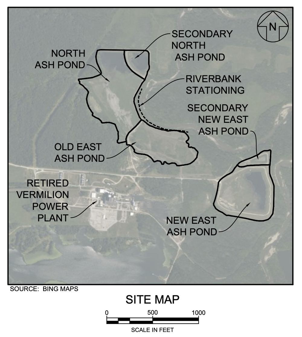
Aerial site map of the retired Vermilion Power Station showing the North, Secondary North, Old East, New East and Secondary New East ash ponds, the retired plant, and the riverbank stationing along the Middle Fork of the Vermilion River.

Timeline

Agency oversight and agreed commitments
2011The Vermilion Power Station which opened in 1955, retires after 56 years.
2018Vistra acquires Dynegy Midwest Generation, including the retired plant property.
June 2021A court-entered Agreed Interim Order requires dewatering, a groundwater collection trench, and a Safety Emergency Response Plan (SERP).
Jan 2022DMG files applications with Illinois EPA for permits to close the ash ponds by removal.
June 2023A Consent Order resolves the state enforcement action, requires closure by removal, and funds local environmental projects.
2023–2026In accordance with the SERP plan, preemptively the company obtained federal and state permits for riverbank stabilization should it be needed; and monitoring continues.

Where things stand today. DMG has met its obligations under both the Agreed Interim Order and the 2023 Consent Order. Permanent closure cannot begin until Illinois EPA issues the necessary permits. Until then, the site stays under weekly, monthly, and quarterly inspection, and the interim protective measures to secure the ponds and stabilize the riverbank are occurring.

Closure permit applications have been with Illinois EPA since January 2022.

The Permanent Solution: Agreed By All Parties

What the 2023 Consent Order requires
The 2023 Consent Order, agreed to by DMG, the Illinois Attorney General, and the Vermilion County State’s Attorney, with input from the local environmental nonprofit Prairie Rivers Network, agreed to an environmentally sound method that protects the community and the river. Work will begin as soon as Illinois EPA approves the company’s permits.
The parties agreed it was the best way to protect the Middle Fork of the Vermilion River over the long term given the unique specifics of this site. Once work starts, the permanent closure of the ash pond is expected to take approximately 12 years to complete.
1. Remove the ash & demolish the old plantAll coal combustion residuals are excavated from the three ponds and the former plant will be demolished.
2. Move the ash away from the river & secure itThe material is placed in a new on-site landfill at the location of the former plant.
3. Restore the areaThe riprap is removed and the riverbank is returned to a naturalized condition under an approved restoration plan.
The company has adopted a preventive approach focused on protecting the adjacent river and wildlife area by keeping the coal ash stable and secure until we can implement the permanent solution.

Protections Already Implemented by the Plant

Steps completed while awaiting closure permits
1. Free water removedUnder an Illinois EPA-approved Dewatering Plan, standing water was pumped out of the ash ponds and dewatering continues until closure is completed.
2. Groundwater trench and sheet pilingA collection trench keeps groundwater from moving through the ash and into the river. Sheet piling installed during construction adds another physical barrier between the ponds and the riverbank.
3. Continuous inspection programWeekly, monthly, and quarterly inspections track embankment condition, water levels, erosion, and any sign of a release. Results are reported to agencies and published online.
4. Materials and designs staged in advanceConstruction-ready stabilization designs were prepared years ago, and roughly 750 tons of riprap has been stockpiled on site since 2023 so crews can respond quickly.
Agreed to and overseen by relevant experts: these measures were required by the Agreed Interim Order and the SERP and were reviewed and approved by Illinois EPA.

How the Riverbank is Monitored

A measured, documented, and public record
Weekly · Embankment inspectionsA qualified inspector walks the ash pond embankments, slopes, and spillways, checking for structural weakness, cracking, failed vegetation, or any visible release.
Monthly · Precise erosion measurementA professional engineer or trained inspector surveys a line of five-foot steel measuring rods set every 25 feet along the riverbank. The rods make it possible to measure how far the bank has moved, to the inch.
Quarterly · Drone survey of the full bankA drone photographic survey documents the entire length of the riverbank and is filed with that month’s inspection report, creating a visual record over time.
A transparent record: Written reports go to Illinois EPA and the Illinois Department of Natural Resources and are published at luminant.com/ccr.

Why this Stabilization Work is Happening Now

Acting early, by design
Riverbanks erode. On a free-flowing river like the Middle Fork, the channel naturally shifts and the bank moves back over time. It happens on both sides of the river, and it has been happening here for decades.
Because of that, engineers set an action threshold years ago, a measured point along the bank at which reinforcement should begin. It was deliberately drawn far back from any point of actual risk: at the threshold, the embankments continue to perform as designed, with strength and capacity to spare.
Recent monitoring shows that natural erosion has reached the preset threshold along a short segment of the bank. The plant will now place the stone that has been sitting on site, waiting since 2023, along up to 500 feet of the riverbank to stabilize the area and prevent further erosion.
What this meansCrews will place riprap along a short section of riverbank, following a design that was prepared, reviewed, and permitted well in advance. The work is temporary, but the interim safety measure will remain in place until the ponds are permanently closed.
What this does not meanThere has been no release, no breach, and no change in the condition of the ash ponds. The embankments continue to perform as designed, with strength and capacity to spare. This is a preventative, not emergency response.
Built-in safety margin: the threshold is set so that reinforcement begins while the riverbank still holds strength in excess of its required load and action is taken before the ash ponds could be affected.

What the Project Involves

A new low stone buttress at the base of the bank
Up to 500 feet of riverbankAlong the Old East Ash Pond, tying into gabion baskets and sheet piling already in place.
IDOT RR-7 riprapHard, angular quarry stone selected because it will not break down in water or with weathering.
About 2,600 cubic yards of stonePlaced as a low buttress at the base of the bank, at least two feet thick.
Fabric and erosion controlsGeotextile separator fabric beneath the stone; straw wattles to control sediment during construction.
Naturalized GrowthThe riprap will be naturalized with vegetative screening that grows over the upcoming years.
Temporary by designThe riverbank will be restored and the stone removed once the coal ash is permanently relocated.
Simplified cross section of the riverbank showing the ash pond embankment, the existing sheet pile and gabion baskets, the new riprap buttress at the base of the slope, and the Middle Fork of the Vermilion River.
Simplified cross section — not to scale.

Reviewed and Permitted in Advance

Four agencies had to sign off before this work could begin

U.S. Army Corps of EngineersClean Water Act Section 404. Authorized under Nationwide Permit 13, which covers bank stabilization projects up to 500 feet. First issued January 2024 and re-verified in March 2026.
National Park ServiceWild and Scenic Rivers Act, Section 7(a). Determined in December 2023 that the project will not have a direct and adverse effect on the free-flowing condition, water quality, or outstanding values of the river, subject to conditions.
Illinois Department of Natural ResourcesAuthorization for Incidental Take. Issued June 2025 with an Implementing Agreement covering protected mussel and fish species, crew training, and post-construction reporting.
Illinois EPASection 401 Water Quality Certification. The certification issued in December 2025 determined that the interim measure would not pollute or impair water quality.

Protecting Mussels and Other Wildlife

The first phase of work, before any stone is placed

1. Survey firstProtected mussel and fish species are known to live in this stretch of the Middle Fork. Before any equipment enters the water, a qualified survey determines whether protected species are present in the project footprint.
2. Relocate all native mussels safelyAll native mussel species will be relocated.
3. Train every workerAll on-site personnel are briefed on which species may be present, where they are found, how to report a sighting, and what to do if one is encountered.
4. Check back over timeFollow-up surveys are conducted one year and three years after construction and again one and three years after the riprap is eventually removed.
Why this comes first. Mussel survey and relocation is the opening phase of the schedule, not an afterthought. It can add up to about a month before construction begins. DMG must notify IDNR when construction starts and finishes, and file a status report within 90 days of completion documenting any species relocated.

Total Project Schedule: About 10 Weeks

Draft sequence of work

Notice of mussel survey / relocation2.5 weeks
Mussel survey and relocation2 weeks
Site preparation1.5 weeks
Riprap placement3 weeks
Site restoration1 week
This is a draft schedule, but construction work will begin after Labor Day 2026. Actual dates depend on river and weather conditions and on the results of the protected species survey. Start and completion dates will be shared with the agencies, and shared locally, before work begins.

What Neighbors and River Users Will Notice

Short-term, visible, and limited to the work area

More truck traffic, brieflyA short-term increase in truck traffic on site access roads while additional stone and equipment are delivered.
Visible activity near the pondsCrews, vehicles, staged material, and erosion-control measures will be visible from the river and nearby property.
Caution signageTemporary signs will be posted on site and along the affected stretch of river asking the public to use caution.
Brief river closuresShort closures of this stretch of river may be imposed by IDNR while stone is placed or equipment is staged or operating.
Recreation kept in mindWherever possible, work will be sequenced to minimize disruption to paddling, fishing, and other river use.
Public safety in the river and around the work area is the top priority. Please observe posted signage and any on-water direction from crews or IDNR.

After the Work is Done

Oversight does not stop when the equipment leaves

1. Monitoring continuesInspections carry on as before, and now also track the condition of the riprap.
2. Reports keep flowingResults continue to go to Illinois EPA and IDNR, and reports remain publicly posted online.
3. The riprap is suppplemented with vegetation Native plantings will establish and grow alongside the stone over the next several seasons.
4. Wildlife is checked againA status report goes to IDNR within 90 days of completion, with follow-up species surveys at one and three years.
5. The stone comes outOnce the ash is gone and the ponds are closed, the riprap is removed — a condition of both the Park Service and Corps of Engineers approvals.
6. And oversight continues for decadesEven after the ponds are permanently closed and the riprap is gone, this site remains under long-term monitoring, inspection, and reporting

Frequently Asked Questions

No. There has been no release, no breach, and no change in the condition of the ash ponds. The embankments continue to perform as designed, with strength and capacity to spare. This is a preventative, not emergency response.

Riverbanks erode. On a free-flowing river like the Middle Fork, the channel naturally shifts and the bank moves back over time. Engineers set an action threshold years ago, a measured point along the bank at which reinforcement should begin. It was deliberately drawn far back from any point of actual risk: at the threshold, the embankment still carries 1.5 times the load required of it. Recent monitoring shows that natural erosion has reached the preset threshold along a short segment of the bank.

Yes. Under the 2023 Consent Order, all coal ash will be removed from the ponds once Illinois EPA issues closure permits. All coal combustion residuals are excavated from the three ponds and the former plant will be demolished, and the material is placed in a new on-site landfill at the location of the former plant. Once work starts, the permanent closure is expected to take approximately 12 years to complete.

Permanent closure cannot begin until Illinois EPA issues the necessary permits. DMG filed applications with Illinois EPA in January 2022 for permits to close the ash ponds by removal. Work will begin as soon as Illinois EPA approves the company’s permits.

Four agencies. The U.S. Army Corps of Engineers authorized the work under Clean Water Act Section 404, Nationwide Permit 13, first issued January 2024 and re-verified in March 2026. The National Park Service determined in December 2023 that the project will not have a direct and adverse effect on the free-flowing condition, water quality, or outstanding values of the river, subject to conditions. The Illinois Department of Natural Resources issued an Authorization for Incidental Take in June 2025. Illinois EPA issued a Section 401 Water Quality Certification in December 2025 determining that the interim measure would not pollute or impair water quality.

No. The stone / riprap placed now is temporary and comes out after the permanent closure is completed. The riverbank will be restored and the stone removed once the coal ash is relocated. Removal is a condition of both the Park Service and Corps of Engineers approvals.

A qualified inspector walks the ash pond embankments, slopes, and spillways weekly. Monthly, a professional engineer or trained inspector surveys a line of five-foot steel measuring rods set every 25 feet along the riverbank, making it possible to measure how far the bank has moved, to the inch. Quarterly, a drone photographic survey documents the entire length of the riverbank. Written reports go to Illinois EPA and the Illinois Department of Natural Resources and are published at luminant.com/ccr.

Protected mussel and fish species are known to live in this stretch of the Middle Fork. Before any equipment enters the water, a qualified survey determines whether protected species are present in the project footprint. All native mussel species will be relocated. All on-site personnel are briefed on which species may be present and what to do if one is encountered. Follow-up surveys are conducted one year and three years after construction and again one and three years after the riprap is eventually removed.

Short closures of this stretch of river may be imposed by IDNR while stone is placed or equipment is staged or operating. The plant is in coordination with IDNR to minimize the disruption to the public’s enjoyment of the river. The community is asked to observe posted signage and any on-water direction from crews or IDNR.

No. The Vermilion Power Station began operations in 1955 and retired in 2011. Vistra Corp. acquired Dynegy Midwest Generation, LLC as part of a 2018 merger, which included the retired plant property; Vistra never operated the plant.

Statement of Dynegy Midwest Generation, LLC, as the site owner

“Since acquiring the retired Vermilion plant property in 2018, the company has prioritized responsible closure of the impoundments to protect the environment, groundwater, the public, and the Middle Fork of the Vermilion River. While awaiting approval to implement the permanent closure plan under the 2023 Consent Order, our team has taken further steps to secure the site and stabilize the existing ash impoundments before the material can be relocated to a new landfill.

Each coal plant is unique, so we have developed a science-based plan to permanently close and secure coal ash residuals at the Vermilion site, tailored to its specific characteristics. Our rigorous monitoring, inspections, and proactive embankment measures reflect our commitment to safety and responsible stewardship, ensuring long-term protection of the river and wildlife areas for generations to come.”

Background
1955 · 2011The Vermilion Power Station began operations in 1955 and retired in 2011.
2018Vistra Corp. acquired Dynegy Midwest Generation, LLC as part of a 2018 merger, which included the retired plant property; Vistra never operated the plant.
2021The property was the subject of state litigation, and before those proceedings began in 2021, the company negotiated with the Attorney General and the State’s Attorney for Vermilion County to develop an Agreed Interim Order detailing steps the plant would take to protect the site until a final plan was developed and approved by all parties.
June 2023To resolve the matter and gain agreement on a permanent closure plan, the company entered into a Consent Order establishing a framework for the closure of the impoundments and providing donations to support local conservation and environmental education initiatives.